This is Dave Zinn with the avalanche forecast for Tueday, March 4th, at 7:00 a.m. sponsored by Polaris and the Yellowstone Club Community Foundation. This forecast does not apply to operating ski areas.
This morning, mountain temperatures are in the teens F, with 5-10 mph winds from the west through the north. The mountains around Bozeman received 2-4” of new snow, with 1-2” in Big Sky and none in the mountains around Cooke City, West Yellowstone and Island Park.
Today, temperatures will be in the mid-20s to low-30s F, with 5-10 mph winds shifting from the northwest to the southwest. By tomorrow morning, a trace to 1” of snow will fall across most of the advisory area. The next chance for significant snow is Thursday.

The mountains around West Yellowstone and Cooke City, including the Southern Madison and Southern Gallatin Ranges, have gone a week without significant snowfall but only three days without a significant avalanche (Lionhead photos and observation). Today, the primary concern is persistent slab avalanches failing on weak layers buried 2-3 feet deep and breaking up to 200 feet wide. Instability on these layers is the most pronounced in the Lionhead area and Southern Gallatin and Southern Madison Ranges, with mid-elevation, non-wind-loaded terrain being the most likely trigger points. In the last two weeks, backcountry riders triggered many avalanches with several burials and close calls (Thursday in Cabin Creek, last Monday in Cooke, last weekend in Tepee Basin 1, Tepee Basin 2, Cooke City, Taylor Fork, and Lionhead two Wednesdays ago).
The odds of triggering an avalanche decrease each day without new snow, but my trust is hard-earned regarding these weak layers buried like active mines on some slopes and inactive ones on many others.
Travel Advice: If you plan to play on slopes steeper than 30 degrees, dig and test for instability. To reduce the consequences of an avalanche, choose slopes with fewer terrain traps, such as trees, cliffs, and gullies. Follow safe travel practices and be ready for an avalanche rescue by carrying and training with beacons, shovels and probes.
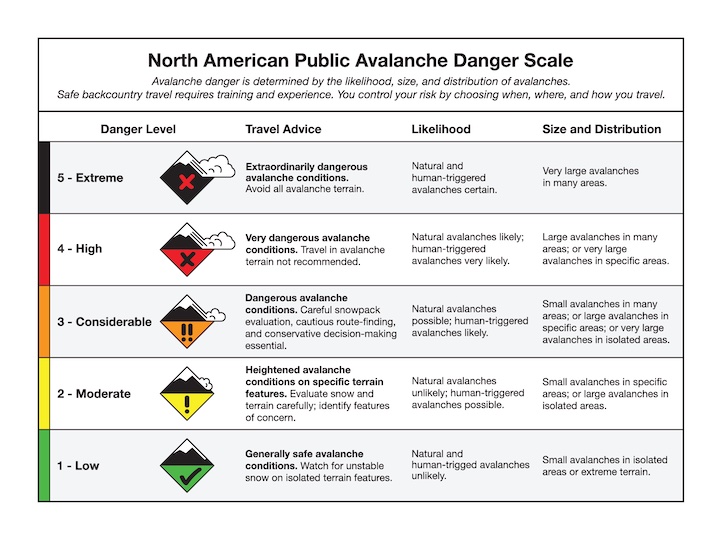
The avalanche danger is rated MODERATE.

Several inches of new snow in the mountains around Bozeman and 1-2” near Big Sky do not significantly change the avalanche danger. Snow showers are forecast to end soon without much more accumulation, and slides today will generally be shallow, isolated to loose snow avalanches or sluffs in steeper terrain and small wind slab avalanches where the snow is drifted. Recognize potential instability by noting shooting cracks and deeper drifts.
As I discussed in my video from the northern Bridger Range yesterday, after backing off our targeted run, many things need to come together to consider steeper and committing backcountry objectives more safely. While most avalanche terrain remains generally stable, a few inches of new snow rewrites the equation in very steep and extreme terrain where small avalanches can have big consequences.
The avalanche danger is LOW.
Avalanches are unlikely in the Centennial Mountains in Island Park. Without recent snow, conditions are generally safe. As I discussed in my video from the Bridger Range yesterday, many things need to line up to consider steep and committing backcountry objectives, including avalanche conditions, snow surface conditions, visibility and partners with the right gear and training. For now, the avalanche conditions component is lined up well. A snowstorm favoring the mountains in Island Park will begin on Thursday, improving riding conditions and increasing the avalanche danger.
Follow standard safe travel protocols and be cautious traveling above or below cornices that can break unexpectedly far back from their edge.
The avalanche danger is LOW.
Upcoming Avalanche Education and Events
Our education calendar is full of awareness lectures and field courses. Check it out: Events and Education Calendar
Every weekend in Cooke City: Friday at The Antlers at 7 p.m., Free Avalanche Awareness and Current Conditions talk, and Saturday from 10 a.m.-2 p.m. at Round Lake Warming Hut, Free Rescue Practice.